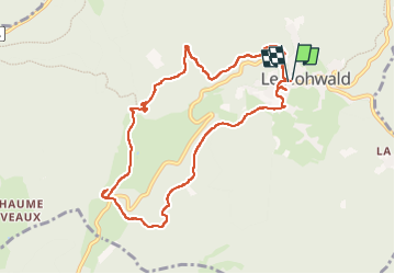
Randonnée Marche Le Hohwald - Hohwald Zundelkof  - Photo
 ROPPJP
ROPPJP

Utilisateur

© OpenStreetMap contributors
Longueur
Longueur
9,6 km
Altitude max
Altitude max
764 m
Dénivelé positif
Dénivelé positif
242 m
Km-Effort
Km-Effort  
12,8 km
Altitude min
Altitude min
585 m
Dénivelé négatif
Dénivelé négatif
245 m
Boucle
Boucle
Oui
Date de création :
2022-06-01 10:58:52.218
Dernière modification :
2022-06-04 09:03:01.383

(0 Avis)

Marche
Marche
3h02
Difficulté : Difficile

Scannez ce code QR pour ouvrir la randonnée dans l'application SityTrail

Application GPS de randonnée GRATUITE

Logo SityTrail SityTrail

IGN / Instituts géographiques

Télécharger SityTrail sur l'App Store Télécharger SityTrail sur Google Play

Logo SityTrail SityTrail World

Le monde est à vous

Télécharger SityTrail sur l'App Store Télécharger SityTrail sur Google Play Télécharger SityTrail sur Huawei AppGallery

À propos

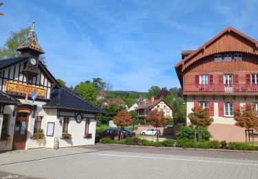
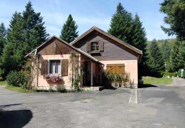
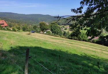
Randonnée Marche de 9,6 km à découvrir à Grand Est, Bas-Rhin, Le Hohwald. Cette randonnée est proposée par ROPPJP.

Description

Départ du Hohwald. Passage au camping. Cascade de l'Andlau. Passage près de la Zundelhutte, lieu de naissance de mon père. Retour par le versant opposé. Sortie sympa, le plus souvent en forêt.

Profil altimétrique

Photos

Localisation

Pays :
France
Région :
Grand Est
Département/Province :
Bas-Rhin
Commune :
Le Hohwald
Localité :
Unknown
Départ:(UTM)
376003 ; 5362517 (32U) N.

Randonnées à proximité

Randonnée Marche Le Hohwald - 2024-04-27 Marche Cascade du Hohwald Champ du Feu - Photo
Marche
GUIDE
holtzv

Marche

Moyen
Le Hohwald, Grand Est, Bas-Rhin, France
20 km | 31 km-effort
6h 58min
Oui
Randonnée Marche Reichsfeld - 2019-12-28 Marche Reichsfeld Ungersberg Gruckert - Photo
Marche
GUIDE
holtzv

Marche

Très facile
Reichsfeld, Grand Est, Bas-Rhin, France
12,2 km | 20 km-effort
3h 5min
Oui
Randonnée Marche Le Hohwald - Tour du Hohwald - Photo
Marche
zazie

Marche

Moyen
(1)
Le Hohwald, Grand Est, Bas-Rhin, France
8 km | 11,3 km-effort
2h 26min
Oui
Randonnée Marche Ottrott - 2013-12-29 Marche Mt Ste Odile Maennelstein Birkenfels - Photo
Marche
GUIDE
holtzv

Marche

Moyen
(1)
Ottrott, Grand Est, Bas-Rhin, France
10,8 km | 15,4 km-effort
3h 24min
Oui
Randonnée Marche Le Hohwald - Hohwald - Rothlach - Neuntelstein - Photo
Marche
VacheKiri67

Marche

Moyen
Le Hohwald, Grand Est, Bas-Rhin, France
15,8 km | 22 km-effort
4h 28min
Oui
Randonnée Marche Le Hohwald - le hohwald, boucle
Marche
bemurix

Marche

Facile
Le Hohwald, Grand Est, Bas-Rhin, France
3,4 km | 4,8 km-effort
55min
Oui
Randonnée Marche Le Hohwald - Hohwald (ter) - Photo
Marche
ROPPJP

Marche

Difficile
Le Hohwald, Grand Est, Bas-Rhin, France
11,2 km | 15,6 km-effort
3h 31min
Oui
Randonnée Marche Le Hohwald - Le Hohwald (bis) - Photo
Marche
ROPPJP

Marche

Moyen
Le Hohwald, Grand Est, Bas-Rhin, France
7,9 km | 11,1 km-effort
2h 56min
Non
Randonnée Marche Bellefosse - Col de la Charbonnière - château de la Roche - Bellefosse - Belmont - Photo
Marche
Bart2015

Marche

Très difficile
Bellefosse, Grand Est, Bas-Rhin, France
15,7 km | 24 km-effort
5h 27min
Oui


Fermer
Mes abonnements